 by Larry Lagarde
Mississippi River, Illinois Trail Network & Downtown St. Louis In Sight
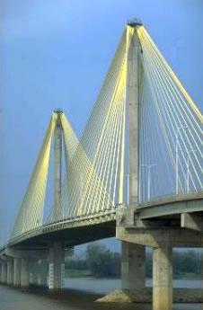
The 225 mile long Katy Trail will soon become 11 miles longer on the eastern end, making a connection to the beautiful William
Clark suspension bridge
tantalizingly close. Spanning the Mississippi River just north of St. Louis, Missouri, the Clark bridge has
10' wide bike lanes
that connect with an extensive bike trail network in Illinois.
(Photo: Clark suspension bridge.)
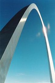 Once on the Illinois side, a cyclist can continue south to the old
Chain of Rocks Bridge
(a historic landmark and formerly a part of Route 66 that is now a bike/ped only trail) and ride across the Chain of Rocks back into Missouri. In fact, this trail leads straight into downtown St. Louis and the
Gateway Arch
.
Once on the Illinois side, a cyclist can continue south to the old
Chain of Rocks Bridge
(a historic landmark and formerly a part of Route 66 that is now a bike/ped only trail) and ride across the Chain of Rocks back into Missouri. In fact, this trail leads straight into downtown St. Louis and the
Gateway Arch
.
Already, the KATY rail trail spans nearly the entire width of Missouri. This new expansion of the trail (plus efforts now underway to link the trail west into Kansas City) mean that the KATY trail will soon be an even larger producer of tourism revenue for Missouri.
 For more about the trail expansion, visit
MoBikeFed.org
. For maps and descriptions of bike trails in and around Saint Louis, visit
RideFinders
. For more about the trail network that extends from the Chain of Rocks bridge, see
Conor Watkin's cycling page
on area trails or try the site for the
Confluence Greenway Trail
.
For more about the trail expansion, visit
MoBikeFed.org
. For maps and descriptions of bike trails in and around Saint Louis, visit
RideFinders
. For more about the trail network that extends from the Chain of Rocks bridge, see
Conor Watkin's cycling page
on area trails or try the site for the
Confluence Greenway Trail
.
(Photo: Chain of Rocks Bridge.)
Labels: bike trails , Chain of Rocks bridge , Clark Bridge , Illinois , KATY Trail , Mississippi River Trail , Missouri , St. Louis , West Alton