|

Folding
Bikes | Places
To Ride | Reviews
| Sitemap
Cycling news & info with a special focus
on notable bike tours, bike trails, bikeways,
lanes and bicycle routes as well as innovative
bicycling products like space saving & easy
to transport folding bikes.
|
Paranoia Of Bicyclists Grips Town
 With many of the 40,000 or so bicyclists that bike the 400 State Trail starting or ending their ride in the little town of Reedsburg, Wisconsin, you'd think the folks of Reedsburg would be happy to provide a couple of tent sites for cyclists. Surprisingly, a story that appeared today in the Wisconsin State Journal tells how unfounded paranoia recently defeated such a proposal.  In a public meeting 2 weeks ago, locals expressed fears of criminal cyclists coming into their town and molesting local children. One resident went so far as to propose that criminal background checks be run on everyone looking to use the proposed tent campsites. It's not as if there has ever been a problem with touring cyclists in this small burg. According to Matt Scott, Reedsburg's director of city parks, in the 12 years he has served as the parks director, he had not heard a single complaint regarding cyclists including the several times when the state's biggest bike tour came through with over 1000 cyclists camping in tents. Additionally, riders must purchase a pass from the local chamber of commerce to ride the trail; yet, only one check out of thousands purchased by cyclists had ever bounced. Hopefully, reason will soon prevail and the people of Reedsburg will approve a site for 3 or so tents that has been proposed in another local park. 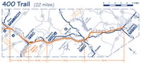 Viewed by many as one of Wisconsin's best long distance cycling routes, the 400 State Trail (click on map to enlarge) is part of a 100+ mile system of interconnected trails in Wisconsin. As the trail runs northwest from Reedsburg to the town of Trempealeau, it's name changes from the 400 State Trail to the Elroy-Sparta State Trail, the LaCrosse River State Trail and finally the Great River State Trail. Labels: 400 State Trail, bike trails, paranoia, rail trails, Wisconsin
Bicycling Ohio's Miami Valley Trail Network
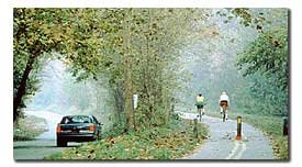
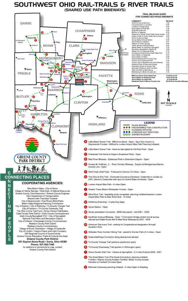
by Larry Lagarde  The Little Miami Trail Network The Little Miami Trail NetworkOne of the most extensive networks of non-motorized, multi-use trail bike trails in the USA can be found in and around Dayton, Ohio. Known collectively as the Miami Valley Trail Network, this series of bike trails extends from eastern Cincinnati to Buck Creek State Park near Springfield. The center of the trail network is the former railroad hub of Xenia, Ohio. From Xenia Station, the Creekside Trail, Jamestown Connector, and the Ohio to Erie Trail radiate out like spokes on a bicycle hub. Including additional connected bike trails, cyclists have access to over 200 miles of non-motorized trails from Xenia. Where: 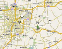 Southwestern Ohio Where to stay: Xenia, Ohio. The trail head there makes it an ideal base for exploring the entire Little Miami network. Following are some recommendations courtesy of Ernie Conner (another bike trail enthusiast) of Gulf Breeze, Florida... Lodging Recommendations: "I recommend the Holiday Inn given its proximity to the trails, but we took the cheap way out and stayed at a Knights Inn. I would stay at the Holiday Inn next time." 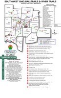 Trail Rides: - Our first ride was north to Springfield via Yellow Springs and a stop at Young's Jersey Dairy for ice cream (38 miles RT). - Our second day was west from Xenia to downtown Dayton via the Creekside and Mad River Trails (39 miles RT). - Our third day was south from Xenia to Corwin, Ohio (39 miles RT). Misc: "Downtown Dayton has a beautiful minor league baseball park only a block or two off the trail. Its a must see. We drove back to Dayton one night and watched a ball game." More information can be found at these websites: Miami Valley Ohio Rails to TrailsExcellent site offering mile by mile descriptions of all 260+ miles of trails in the network including locations of trail heads, parking, water fountains, restrooms, restaurants, ice cream shops, hotels, motels, B&B's & campgrounds near bike trails in the Little Miami Valley. Map & List of Ohio Bikeays Courtesy of ODOTDetailed and up to date information pertaining to all of Ohio's bike lanes, paths and trails including maps, trail mileage and much more. One of the more useful state bike sites I've seen. Bike Miami ValleyA 501 (c)(3) nonprofit advocacy organization dedicated to promoting, enabling and creating safe bicycling for recreation and transportation in a 10-county region known as the Miami Valley in southwestern Ohio. Little Miami State Park50 mile trail corridor owned by the State of Ohio that focuses on bicycling, hiking, cross-country skiing, rollerblading, backpacking and horseback riding. The corridor also provides access to canoeing the Little Miami River. Little Miami Scenic TrailMulti-purpose scenic trail running from Xenia, Ohio to Yellow Springs. Little Miami Scenic Trail Users StudyThis study estimates that there are 150,000 to 175,000 trail visits annually on the 27 mile section between Loveland and Corwin in Warren County, Ohio. Sixty-six percent of trail users are bicycling; 25% are walking or jogging; and 8.5% are in-line skating. These trail users spend approximately $3.1 to $3.7 million annually on trip-related expenditures and trail-related durable goods. Labels: bike trails, Dayton Ohio, great places to go bicycling, Little Miami Trail Network, Ohio
Katy Trail Expansion - Mo' Details
Last week, I reported on a just announced expansion of the Katy Trail in Missouri. Today, I received more details on the project courtesy of Kerri Yap at the Missouri Department of Transportation (Mo DOT)... "Larry, Great Rivers Greenway suggested that I contact the Dept. of Natural Resources to get more information on this project... The extension (from St. Charles) to Machens is actually about 12.6 miles. The distance to the West Alton Trail is approximately (an additional) 7 miles. However, this measurement was taken on the road. It is not a straight-line distance nor does it follow any potential alignment. Currently it is the desire of DNR to connect Katy Trail to the West Alton Trail, however there is nothing planned. As far as a construction schedule goes, DNR hopes for construction to begin late Fall of this year. However, the start date depends on permitting and other variables, so it is very possible for the start date to be a bit later. Given the Fall start, they hope to have the entire stretch to Machens open next summer (2008). Routes for bicyclists between Machens and the West Alton trail are really a matter of preference. Bicyclists are allowed on MO 94, however this might not be comfortable for everyone due to vehicle speeds and constrained shoulders. The majority of the roads in that area are county roads so you might check with them." Trails like the Katy are magnets for vacationing families looking for a safe yet soft adventure. Hopefully, the powers that be at MoDOT, GRG, DNR, etc. will recognize that more families are turning to bicycle tourism and will close that 7 mile gap sooner rather than later. Thanks to Kerri for providing these helpful details. :-) Trails like the Katy are magnets for vacationing families looking for a safe yet soft adventure. Hopefully, the powers that be at MoDOT, GRG, DNR, etc. will recognize that more families are turning to bicycle tourism and will close that 7 mile gap sooner rather than later. Without a doubt, the Katy is a success; however, until the Katy runs into Kansas City or St. Louis, the trail will never reach its full potential. Ride safely. Larry By the way, I'm always looking for first hand reports about bicycling on long distance bike trails. If you rode a trail recently, write me about the experience using my email link at the bottom of this page. If I publish your info, I'll be glad to give you the credit.Labels: bike trails, Clark Bridge, Illinois, KATY Trail, Mississippi River Trail, Missouri, St. Louis, West Alton
Katy Trail Expanding Eastward
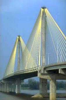
 by Larry Lagarde Mississippi River, Illinois Trail Network & Downtown St. Louis In Sight The 225 mile long Katy Trail will soon become 11 miles longer on the eastern end, making a connection to the beautiful William Clark suspension bridge tantalizingly close. Spanning the Mississippi River just north of St. Louis, Missouri, the Clark bridge has 10' wide bike lanes that connect with an extensive bike trail network in Illinois. (Photo: Clark suspension bridge.)  Once on the Illinois side, a cyclist can continue south to the old Chain of Rocks Bridge (a historic landmark and formerly a part of Route 66 that is now a bike/ped only trail) and ride across the Chain of Rocks back into Missouri. In fact, this trail leads straight into downtown St. Louis and the Gateway Arch. Already, the KATY rail trail spans nearly the entire width of Missouri. This new expansion of the trail (plus efforts now underway to link the trail west into Kansas City) mean that the KATY trail will soon be an even larger producer of tourism revenue for Missouri. 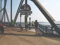 For more about the trail expansion, visit MoBikeFed.org. For maps and descriptions of bike trails in and around Saint Louis, visit RideFinders. For more about the trail network that extends from the Chain of Rocks bridge, see Conor Watkin's cycling page on area trails or try the site for the Confluence Greenway Trail. (Photo: Chain of Rocks Bridge.) Labels: bike trails, Chain of Rocks bridge, Clark Bridge, Illinois, KATY Trail, Mississippi River Trail, Missouri, St. Louis, West Alton
Hiawatha, Coeur d'Alene & Spokane Centennial Trails
A reader contacted me today for help in sketching out an upcoming trip to the Northwest to ride the Spokane River Centennial Trail, the Coeur d'Alene Trail and the Routhe of the Hiawatha Trail. When I was planning my September 2006 trip to ride the Hiawatha, Coeur d'Alene & Spokane River Centennial trails, I was very concerned with the logistics. Initially, my goal was to ride each trail using just a bicycle. My research showed that this was possible; however, it would require a a week to 10 days to do & enjoy. I didn't have that time plus my wife and our infant daughter came along so here's what we did: We took Amtrak from New Orleans to Chicago, changed trains and continued onto Spokane. The train pulls into Spokane just after midnight so we checked into a hotel. The following morning, I rode the Spokane Centennial Trail WEST through Riverside Park. This was a wonderful ride that I highly recommend. We rented a car, packed up our gear and drove east to Wallace, Idaho (a great little mining town). The Coeur d'Alene (CDA) runs through Wallace; I suggest riding the CDA west all the way to Heyburn State Park where there are cabins. The trail enters the park by crossing Chacolet Lake on the old railroad trestle which has been modified with a series of ramps so marine traffic can navigate beneath. Stay at the state park or in Harrison overnight then ride back the following day. The Hiawatha is a short ride but the scenery is wonderful. Pack a picnic lunch and make a day of it. Begin the ride from the East Portal of the Taft Tunnel and continue west, stopping to read the interpretive signs along the way and for photos of the trestles, etc. The last 2 trestles are minor so you won't miss much if you turn around before reaching that point. It is possible to continue riding on the old railbed beyond the ranger patroled limits of the Hiawatha. Just beware that you'll be riding for miles with no services. If you don't want to sweat the details of planning how to ride these stunning bike trails, Loren Dudley with Silver Bike Tours is wonderful. Although I've never met Loren, we spoke by phone and corresponded quite a bit. He was always very helpful, offering various ride suggestions. Loren suggests that cyclists stay in Kellogg over Wallace due to the condo accommodations available at the ski lodge there. I didn't find Kellogg as visually appealing as Wallace and liked the Best Western Wallace (helpful staff, indoor heated pool & jacuzzi, & restaurant/gift shop on site; stay on the 1st floor if you don't want to lug suitcases up stairs...). Frankly, Kellogg & Wallace are only 15-20 minutes from one another so both are centrally located. Labels: bike trails, Coeur d'Alene, Hiawatha, Idaho, Kellogg, Spokane, trail, Wallace, washington area bicyclist association
Places To Go Bicycling - Birmingham, Alabama
by Larry Lagarde Located in north central Alabama with a population of about 250,000, Birmingham is the largest city in this southern state. Founded just after the Civil War as an industrial center, Birmingham is the only place in the world where all the raw materials for producing steel are found in significant quantities. In the first half of the 20th century, B'ham's steel output was so high that it quickly earned the nickname "Pittsburgh of the South." Due to the way Alabama allocates gas taxes and the city's location at the confluence of 3 interstates & 2 US highways, automobile use in Birmingham is among the highest in the USA and has fueled an out migration to the suburbs since the 1960's. With the steel industry waning in the 1970's, the economy of B'ham diversified over several decades into banking, bio-technology, information technology, law, medicine, research and publishing. Over the last 10 years, an urban renewal has taken hold in downtown's art deco skyscrapers and warehouses, revitalizing disused spaces into lofts, condos, retail developments and restaurants. Places To Go Bicycling In BirminghamAccording to Steve Fair with the Birmingham Bicycle Club, the best place to go cycling in Birmingham is the Shades Creek Greenway Trail. In the region, Steve suggests Oak Mountain State Park, Cheaha State Park, Talladega National Forest, Choccolocco Wildlife Management Area, Bankhead National Forest and the Chief Ladiga/Silver Comet trail from Anniston AL. to Atlanta, GA. Shades Creek Greenway TrailRunning alongside Shades Creek in Homewood, this paved trail offers plenty of shade and picnic spots on a hot summer day. Fairly level, this is a family oriented trail within the city and very near to Brookwood Mall. No cars are allowed on the trail which is presently 5 miles long. Oak Mountain State ParkOak Mountain S.P.'s 17-mile Red Trail loop attracts mountain bikers from as far away as Florida and Louisiana. Built in 1993 by the Birmingham Urban Mountain Peddlers (BUMP), this combination of single track and an old two-lane fire road offers grueling climbs, rocketing downhills and hairpin turns, with sheer drops off the sides and an elevation gain of up to 500'. Several trailheads offer parking & access to the loop. For those wanting a more relaxed road ride, there is also a bike lane running on the side of Oak Mountain's main road. The lane passes 3 lakes and wooded areas with plenty of wildlife including turkeys and deer. Although the bike lane has several minor climbs, the length of these stretches will grab your attention. Total distance round trip is about 15 miles. The popularity of the Red Trail has led to other nearby state parks, national forests and wildlife management areas opening trails to mountain bikers. Cheaha State Park has completed a mountain bike trail, the Kentuck Off-Road Trail has opened in the Talladega National Forest as has a trail at the Choccolocco Wildlife Management. Currently, 30 miles of off-road vehicle trails are being built at the Bankhead National Forest. Chief Ladiga/Silver Comet Rail TrailsThose who are interested in traveling a few miles should consider riding the Chief Ladiga Trail 70 miles northeast of B'ham in Anniston. Currently, the trail currently goes from Anniston to Piedmont, stopping just 8 miles short of the Georgia line; however, paving work on that section is currently under way. When that work has been completed in coming months, the Chief Ladiga will connect seamlessly with the Silver Comet Trail. Cyclists will then be able to bike on a paved, non-motorized trail all the way to Smyrna (a suburb of Atlanta). The current distance for the Alabama section is 25 miles (one way). Since the trail is built on an abandoned rail line, the steepest grade is around 2%, making the trail inviting for families. Picnic spots are easily accessed by car in Jacksonville and Piedmont too. More Bicycling InfoEach weekend and several evenings every week, the Birmingham Bicycle Club sponsors rides of varying difficulty and distance. For information, call Homewood Cycle at 205-879-3244. More About BirminghamFor more about other attractions or accommodations in this diverse city, contact the Greater Birmingham CVB at 205-458-8000. My special thanks go to Vickie Ashford and Steve Fair for their help & suggestions. Labels: Alabama, bike trails, Birmingham, BUMP, Chief Ladiga, NEABC, Oak Mountain, places to go bicycling, Shades Creek Greenway, Silver Comet, trails
Silver Comet & Chief Ladiga Trails Connecting Soon
During a meeting this week with Jeff Ciabotti, Vice President of Trail Development for the Rails To Trails Conservancy (RTC), I learned that construction is now underway to complete the final connecting sections of the Chief Ladiga and Silver Comet rail trails at the Alabama - Georgia state line. Upon completion of this project, a cyclist will be able to ride all 101 miles from Smyrna (a suburb of Atlanta, Georgia) to Anniston, Alabama on a smooth, non-motorized rail trail. Since Atlanta and Anniston are both served by Amtrak's Crescent, cyclists will be able to ride one way and take the train back. Although there are many bike trails throughout the USA, the number of interstate trails is small; thus, the opening of this connector is quite an event. In fact, both the governors of Alabama & Georgia are expected to attend the ceremony as are key figures from Washington, D.C. (like Jeff) and representatives of corporate sponsors of the project (like Coca Cola) and stake holders (such as Atlanta's PATH Foundation). During a meeting yesterday with Jeff, I proposed that we promote the ribbon cutting event to members of the RTC from around the nation as well as to cyclist organizations across the Deep South. Jeff suggested I begin by getting an update on the construction progress from project manager Shannon Robbins. According to Shannon, the wet weather they've been experiencing this Winter has turned the work area into a muddy mess. As a result, the work on the rail trail may not be complete until mid July '07 amd no date has been announced for the ribbon cutting event at the Coca Cola kiosk being built at the state line. I'm planning to ride the Chief Ladiga & Silver Comet and will be timing my visit to coincide with the ribbon cutting. If you'd also like to attend, either email me or check my site periodically as I will be publishing more details about the event as they become available. As I plan to take Amtrak to the event, I'll also begin to publish info about places to go bicycling along the route of the Crescent from New Orleans to Atlanta (and perhaps even beyond). Larry Labels: Alabama, Anniston, Atlanta, bike trails, Chief Ladiga Trail, Coca Cola, Georgia, great places to go bicycling, PATH Foundation, rail trails, Rails To Trails Conservancy, Silver Comet Trail, Smyrna
Living Car Free In Los Angeles
 Did you know that in Los Angeles, the average time a driver spends in traffic totals a ridiculous two and a half weeks per year? Glen Janken is a 55 year old native of Los Angeles that's had it with L.A.'s notorious traffic. He's resolved to use alternate transportation like buses and bikes to get around. Yesterday, Glen wrote about a recent shopping excursion. He rode his bike 30 miles to the store then rode the bus back, placing the bicycle on the bike rack on the front of the bus. The most interesting point concerning Glen's journey is that his return journey by bus took as long as the bike ride to the store. Glen believes that the lack of stop signs or traffic signals on the bike trail combined with the bus having to go through traffic is why the travel times were the same. Following are some useful sites for living without a car in Los Angeles: Glen Janken's car free L.A. lifestyle blog... fixlatraffic.blogspot.comCarFreeLA.com offers a variety of articles about living in Los Angeles without a car. The LADOT offers info on bikeways and local transit services. Labels: bike trails, bikeways, car free living, Los Angeles, mass transit, multi modal, transportation
Folding
Bikes | Places
To Ride | Reviews
| Sitemap
RideTHISbike.com
Cycling
for fun, fitness & practicality.
PO Box 9025,
Bridge City, LA. 70094
Ph: 504-324-2492
Email
Us
© 2005-2010 Areafocus.com.
All rights reserved.
Website Terms & Conditions
|
|


 With many of the 40,000 or so bicyclists that bike the 400 State Trail starting or ending their ride in the little town of Reedsburg, Wisconsin, you'd think the folks of Reedsburg would be happy to provide a couple of tent sites for cyclists. Surprisingly, a story that appeared today in the Wisconsin State Journal tells how unfounded paranoia recently defeated such a proposal.
 In a public meeting 2 weeks ago, locals expressed fears of criminal cyclists coming into their town and molesting local children. One resident went so far as to propose that criminal background checks be run on everyone looking to use the proposed tent campsites.
 Viewed by many as one of Wisconsin's best long distance cycling routes, the 400 State Trail (click on map to enlarge) is part of a 100+ mile system of interconnected trails in Wisconsin. As the trail runs northwest from Reedsburg to the town of Trempealeau, it's name changes from the 400 State Trail to the Elroy-Sparta State Trail, the LaCrosse River State Trail and finally the Great River State Trail.