|
Albuquerque,
New Mexico is renowned for its
pleasant year-round climate. Although
located at about the same latitude
as Las Vegas, Albuquerque's 5000'
high altitude results in mild, dry
days & cool nights, making it an enjoyable
place to bicycle during any season.
Breath taking scenery (the city hugs
the western side of 10,400' high Sandia
Peak), miles of paved, car-free bike
trails (such as the Bosque along the
Rio Grande River), genuine frontier
appeal, a hip college vibe and great
air connections all combine to make
Albuquerque an excellent, affordable
cycling destination.
Like
New Orleans, Albuquerque is one of
the few places where you can get off
the plane, unfold your bike and start
cycling right from the airport.
Cycling
From The Airport
 From
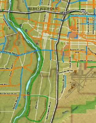
the terminal, head down Sunport Blvd.
and make a left on University Blvd.
From there, a bike lane runs south
(see the blue line on University Blvd.
on Albuquerque's
bicycle trail/route map). The
lane only goes a few miles but there
is very little traffic so the rest
of the road is fairly safe to ride
on. After University Blvd. passes
below I-25, it becomes Rio Bravo Blvd.
Continue west on Rio Bravo until the
intersection of Broadway Blvd., then
begin looking for the Rio Bravo Trail
on your left. From
the terminal, head down Sunport Blvd.
and make a left on University Blvd.
From there, a bike lane runs south
(see the blue line on University Blvd.
on Albuquerque's
bicycle trail/route map). The
lane only goes a few miles but there
is very little traffic so the rest
of the road is fairly safe to ride
on. After University Blvd. passes
below I-25, it becomes Rio Bravo Blvd.
Continue west on Rio Bravo until the
intersection of Broadway Blvd., then
begin looking for the Rio Bravo Trail
on your left.
Rio
Bravo Trail
The Rio Bravo is a loop trail and
is less scenic than other trails like
the Bosque. My suggestion is to continue
west on the Rio Bravo Trail and use
it as a connector to the Bosque Trail.
When the Rio Bravo meets the Bosque,
turn right and you will be heading
north along Albuquerque's most popular
trail.
Bosque
Trail
The Bosque Trail is the backbone of
the Albuquerque's bicycle trail system.
Almost completely flat and requiring
very little street riding, this recreational
trail along the Rio Grande offers
tranquil riding in urban and semi-urban
environments. In the desert southwest,
flowing waterways such as the Rio
Grande are a treasure, fostering forests
of tall Cottonwoods and sustenance
for wildlife such as lizards, roadrunners
and even pheasants. The Bosque allows
riders to experience & enjoy this
environment.
 Route
66 & Old Town Route
66 & Old Town
Ride the Bosque about 5 1/2 miles
north and the trail intersects with
one of the best preserved segments
of Route 66, one of the world's most
storied highways. The Bosque passes
beneath Route 66 (known locally as
Central Ave.) so cyclists can ride
unimpeded; however, this junction
marks the southwest corner of Albuquerque's
historic heart, Old Town. Attractions
such as the original Central Plaza,
San Felipe de Neri church, centuries
old adobe buildings, art galleries,
cafes, the Albuquerque Aquarium, the
Botanical Garden, NM Natural History/Science
Museum, the Children's Museum and
more are all just a few short blocks
away; therefore, cycling tourists
will want to leave the trail here
to site see at the very least.
Downtown
Two
kilometers (1.3 miles) east of Old
Town's Central Plaza is Civic Plaza
and Downtown (New Mexico's governmental
hub and Albuquerque's main business
district). Throughout the year, a
variety of events are held at Civic
Plaza; most notable is Summerfest,
a celebration of New Mexico's ethnic
cultures held in June & July.
The Convention Center, Kimo Theater
and luxury hotels are located in this
area. Frequent stoplights regulate
traffic so you could bicycle eastward
into Downtown along Route 66 or follow
the bike route on Grand Ave., a parallel
side street.
Rio
Grande Nature Center, Tranquil B&B
Lodging
When your visit to Downtown is concluded,
follow the Grand Ave. bike route back
to Old Town. Turn right (north) onto
7th St and follow the bike route about
a mile. Turn left (west) onto Mountain
Road; cycle @ 2 miles then turn right
(north) onto Rio Grande Blvd. &
follow the bike lane north through
quiet, pleasant neighborhoods (several
tranquil bed and breakfasts are in
this area). At Candelaria Rd, turn
left (west). Ride half a mile and
you'll reach the Bosque Trail and
the Rio
Grande Nature Center, an outdoor
museum about the Rio Grande ecosystem
with pleasant views of wetlands &
wildlife.
Paseo
del Norte Trail
Leaving the Nature Center, ride another
5 miles north until the Bosque Trail
intersects with the Paseo
del Norte Trail. Turn right onto
the Paseo del Norte and this will
take you east away from the Rio Grande
into Albuquerque's Northeast Quadrant
& towards the mountains. After Edith
Blvd. (1.5 miles along), the trail
climbs noticeably. If you are not
acclimated to the altitude (Albuquerque's
similar to Denver at about a mile
high), you'll probably want to take
this section more slowly.
Albuquerque's
Northeast Quadrant abuts the base
of the Sandia Mountains. Running east
from the Rio Grande to the Sandia
Peak Aerial Tram, this is the largest
area both geographically and by population.
The University of New Mexico, the
Maxwell Museum of Anthropology, the
Uptown area (including both Coronado
and Winrock malls), Journal Center,
Balloon Fiesta Park, Albuquerque Academy
and some of the most affluent regions
of the city are located here.
Journal
Center & the University of New Mexico
Two miles into the Paseo del Norte,
the trail makes a 90 degree turn south
and becomes the Diversion Channel
Trail. At this point, you can exit
the trail and make a short connection
to Jefferson St. and the Journal Center,
one of Albuquerque's business, retail
and lodging areas. The Diversion Channel
continues straight south and is not
very scenic but it is a major connector
to a variety of other bike trails,
routes and lanes. After crossing beneath
I-25, the trail forks. The right fork
leads south to the University
of New Mexico where you can hang
out with about 25k students on the
600 acre campus on old Route 66. The
left fork leads up the Paseo del Nordeste
Trail. Either way, you can connect
via bike lanes and routes to the car
free Paseo de las Montanas Trail and
eventually to the Tramway Trail.
Sandia
Peak
Just minutes from the heart of Albuquerque
is the world's
longest aerial tramway. If you
like mountain biking, the Sandia Peak
Tramway is an effortless and breathtaking
way to reach the top of Sandia
Peak. Even in the dead of summer
when Albuquerque is warm, Sandia Mountain
is cool and inviting. The Peak offers
30 miles of ultimate downhill and
even has a full service bike shop
with rental bikes.
Whether
you spend a day or a week exploring
Albuquerque's many, crisscrossing
bike trails, routes and lanes, cycling
here certainly ranks among the world's
Great City Rides.
Helpful,
Local Cycling Links:
Interactive
Bike Trail Map
Biking
in Albuquerque
New
Mexico Touring Society
New
Mexico Cycling
NOTE:
Special thanks to Brian
Fletcher for his Albuquerque cycling
blog and his help writing this profile.
|

